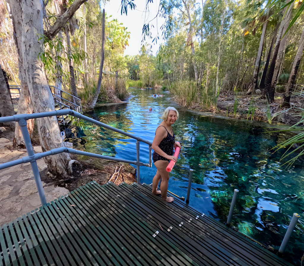
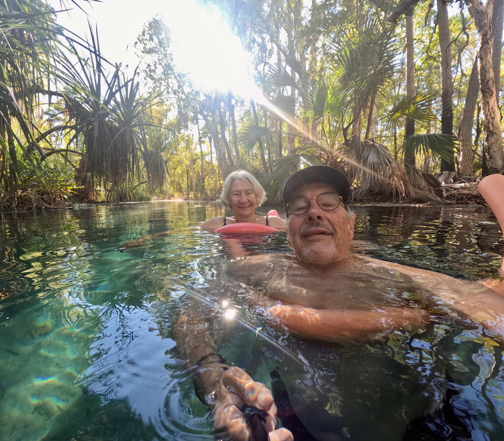
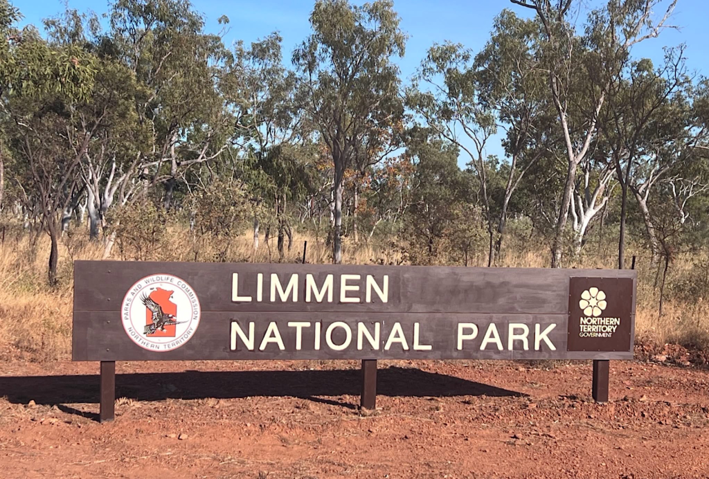
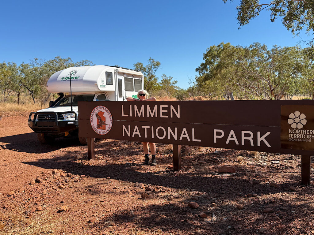
Limmen National Park sits on the western edge of the Gulf of Carpentaria, and the road to get there takes you deep into remote country. Just south of Mataranka, we swung east onto the Roper Highway, but not before making a mandatory stop at one of my all-time favourite places – Bitter Springs, which is in Elsey National Park.
Fed by a thermal spring pumping out a staggering 30.5 million litres a day, it’s going to be the perfect place to slow down before we tackle the long, dusty, bumpy road ahead.
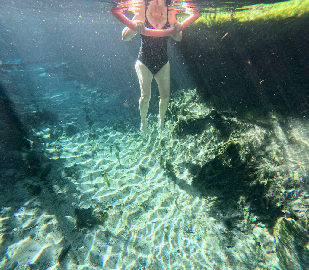
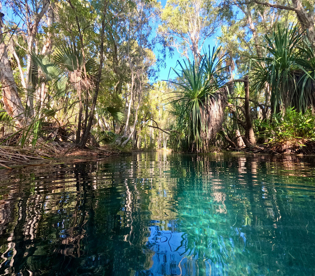
Other than excellent infrastructure to get into and out of the spring it is entirely as nature makes it.The flow from the spring is sufficient to float you the 250m from one end to the other with no effort.The water is crystal clear and a constant 32°C year round.The relaxation felt floating in the warm water past the pandanus and eucalypts is cathartic. I’m sure you can see why I’d never drive past this place without stopping.
Wednesday
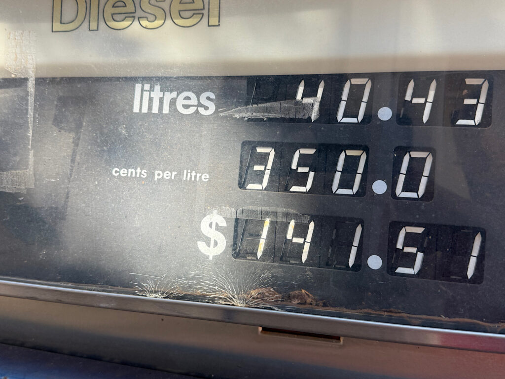
We’ve travelled around 300km since the last opportunity to refuel (at $1.75/litre), and we’ve got long-range fuel tanks, so theoretically we still have sufficient fuel to get us through Limmen NP, including its side trips, and back to civilisation. But … out here it’s not worth the worry, so we topped-up at the Roper Bar Store. This store serves a small remote community.
Peace of mind comes at a price.
Corrugations, many bulldust holes and some rocky stretches with lots and lots of red dirt will be our constant companion now for the next 5 days.
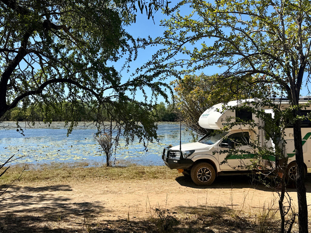
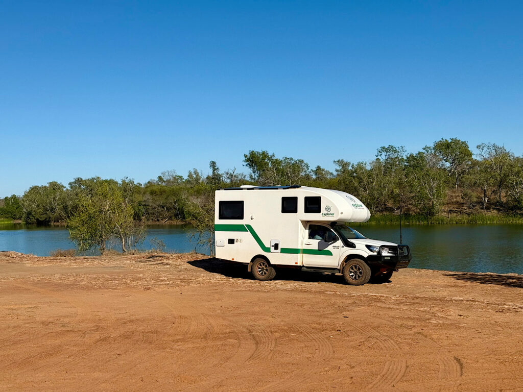
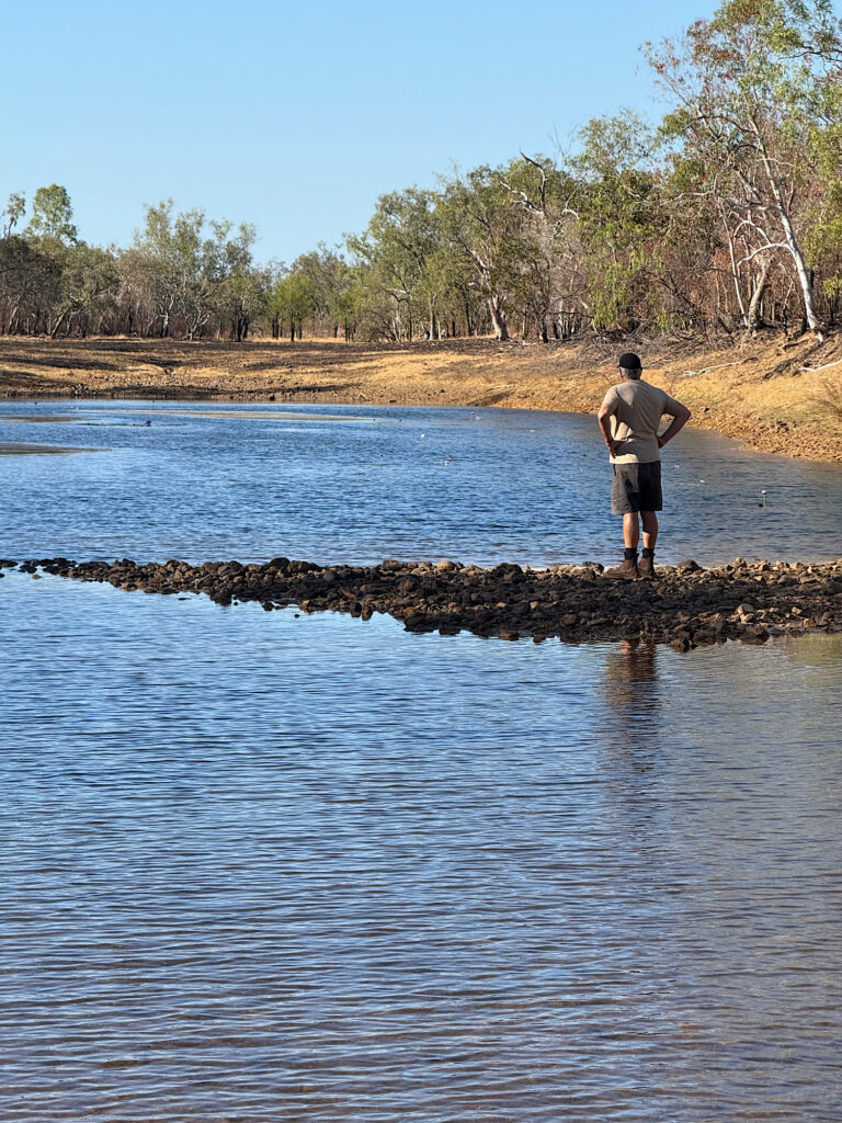
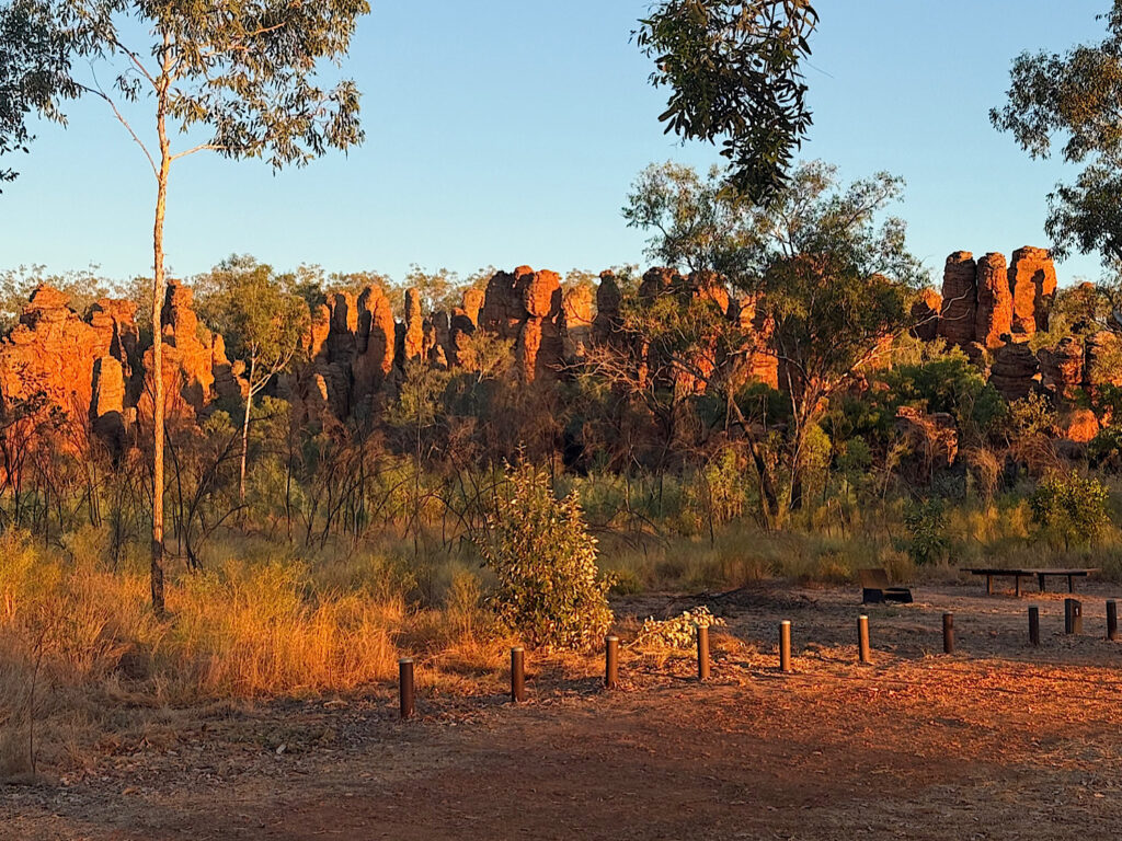
We’re so excited to finally be here. Expectations are high.Lomareium Lagoon lunch stop. We passed several lagoons alongside the road. This lilly-covered one is the prettiest. Apparently the estuarine crocodiles think so too!Towns River. The water is about 2 metres down a rocky ledge – enough to make it difficult for a crocodile to climb up. Lovely camping here, but nevertheless I didn’t venture out after dark when I couldn’t see my surrounds clearly.
Thursday
After a reasonably long but uneventful drive (just adding a water crossing or two to the previous descriptors of the road) we arrived at the Nathan River Ranger Station. No one in attendance but lots of excellent posters on the walls discussing the indigenous and early settler history, the flora, fauna and of course the spectacular geological formations we’re here to see. Also we needed to get the combination for the locked gate into the Western Lost City for tomorrow.
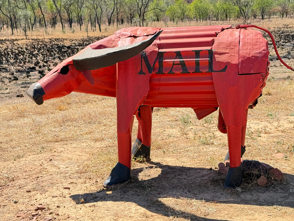
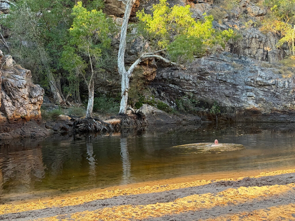
Beside the Ranger Station is an airstrip. Amongst essential services like being a landing strip for the Royal Flying Doctor, the Station gets its mail delivered, and this is their mail box.Butterfly Falls campsite was a little further down the road. After getting settled in we wandered down to the Falls for a lovely refreshing swim in the clear waters after our dusty drive today. A restful evening ensued.
Friday
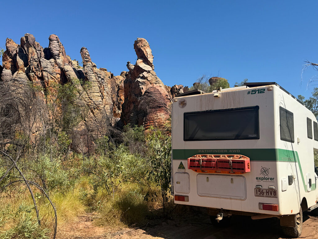
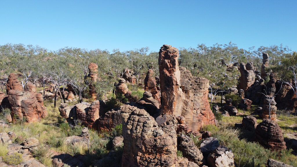
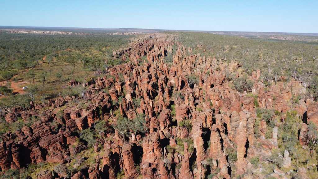
Because of the area’s remoteness, the rough gravel roads—often in poor condition, especially after the wet season—and the need for a tough, high-clearance four-wheel-drive vehicle, few tourists ever visit the Lost Cities in Limmen National Park. In fact, I met very few people who even knew they existed. We feel genuinely privileged to be here.
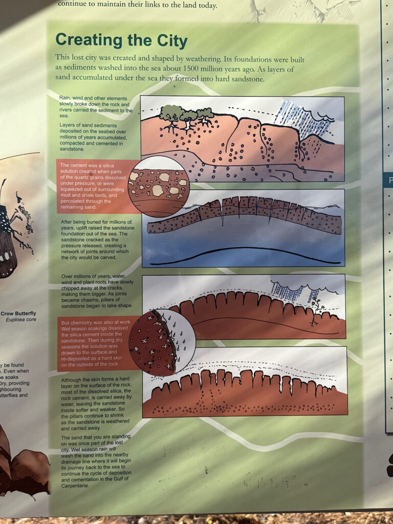
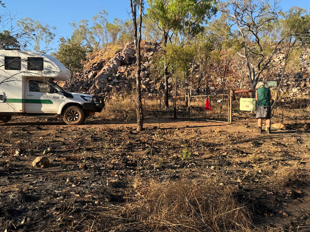
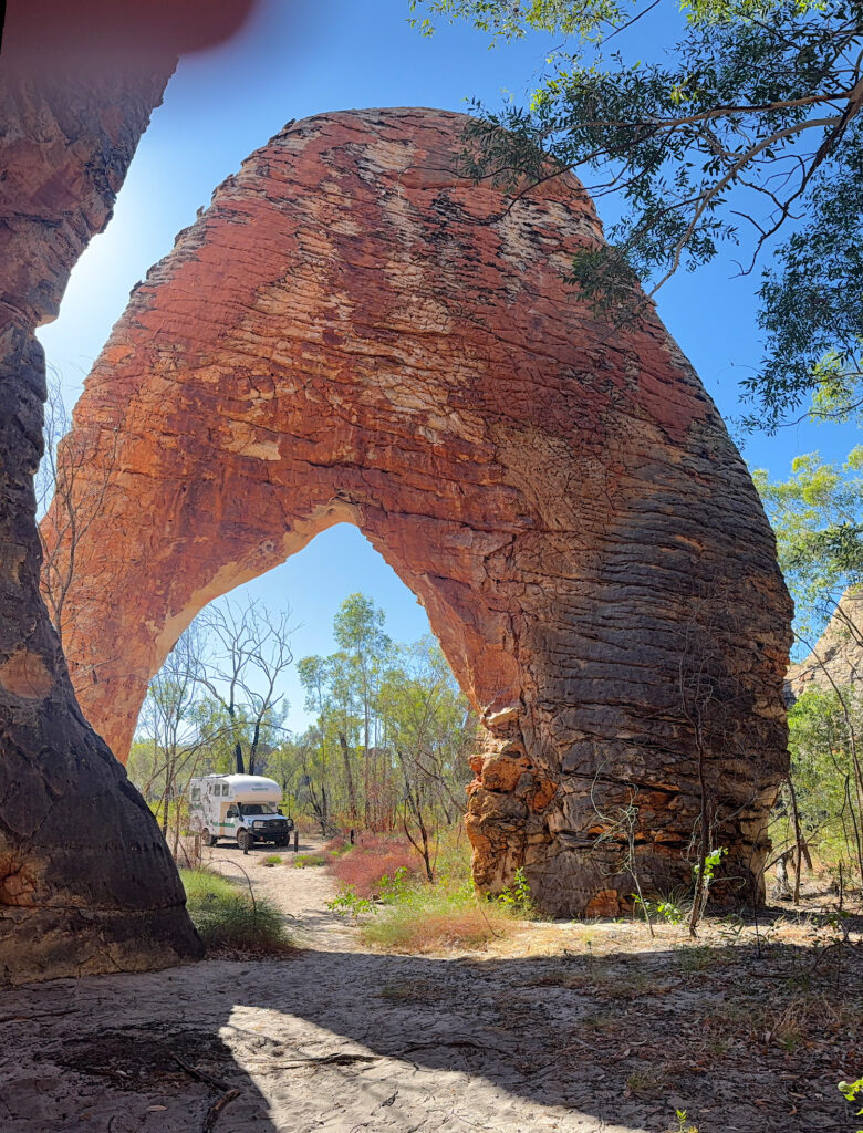
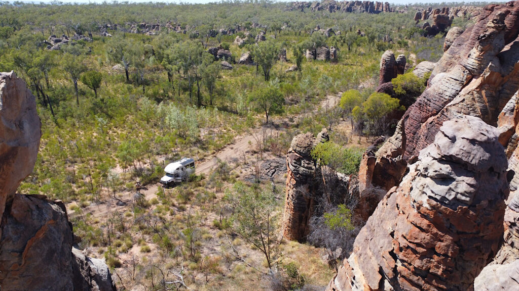
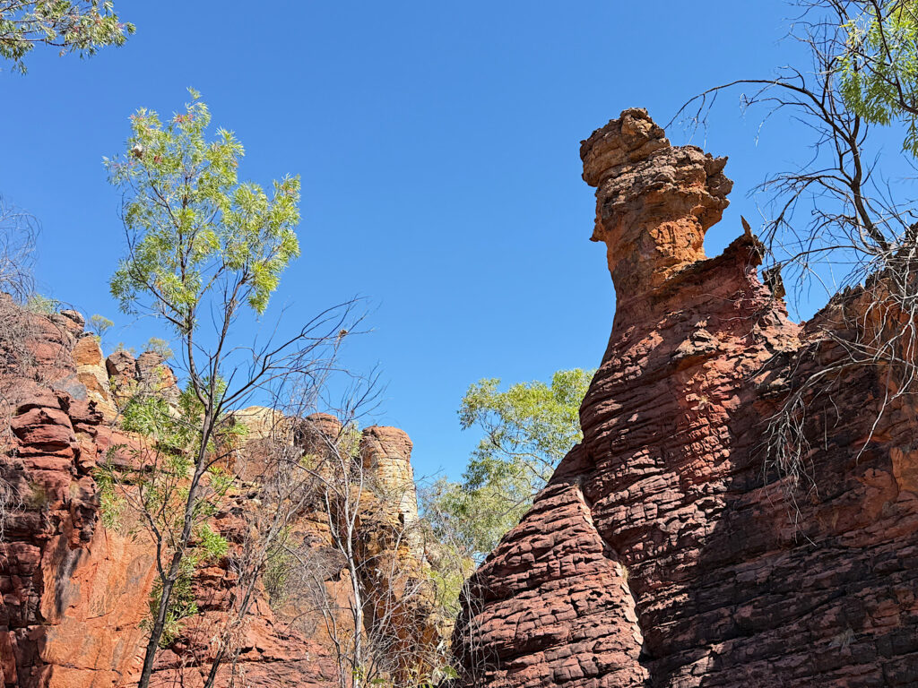
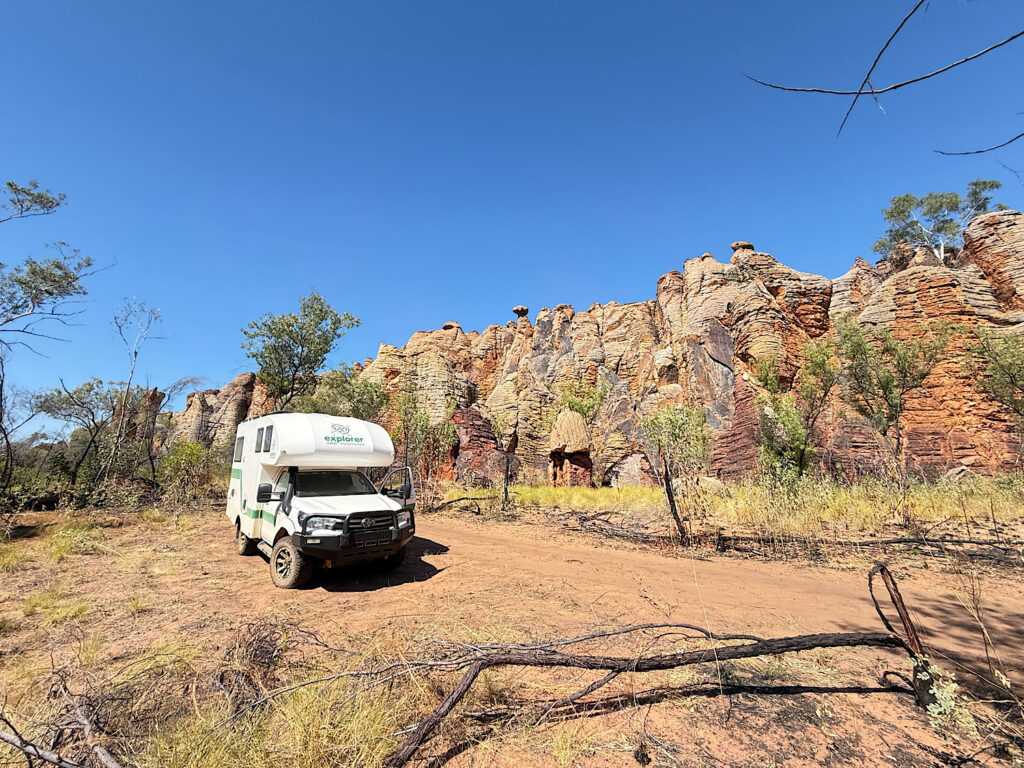
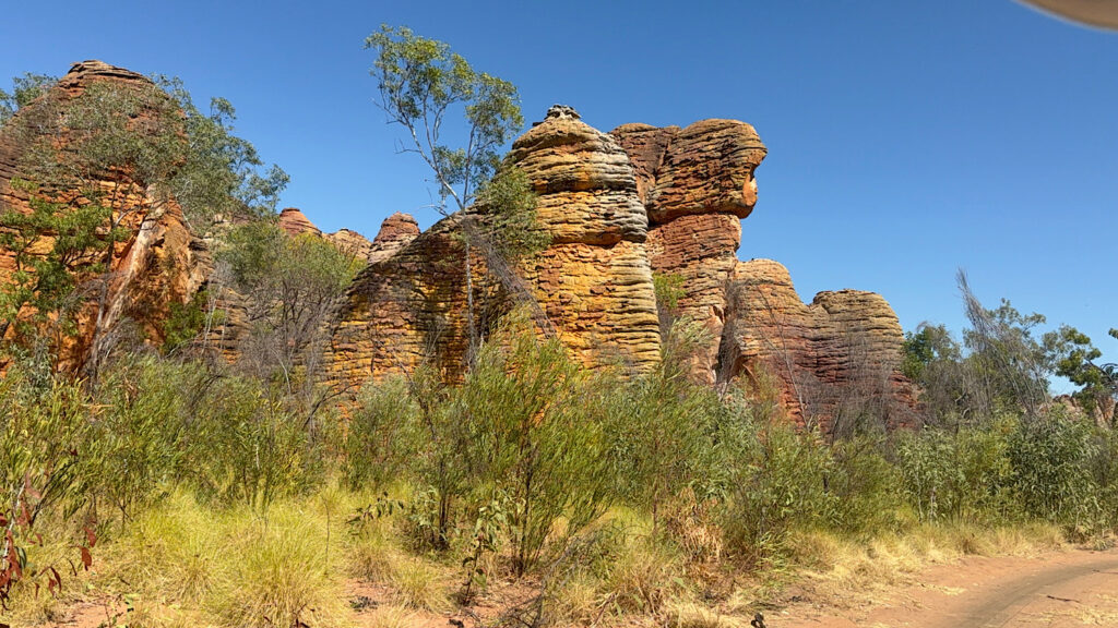
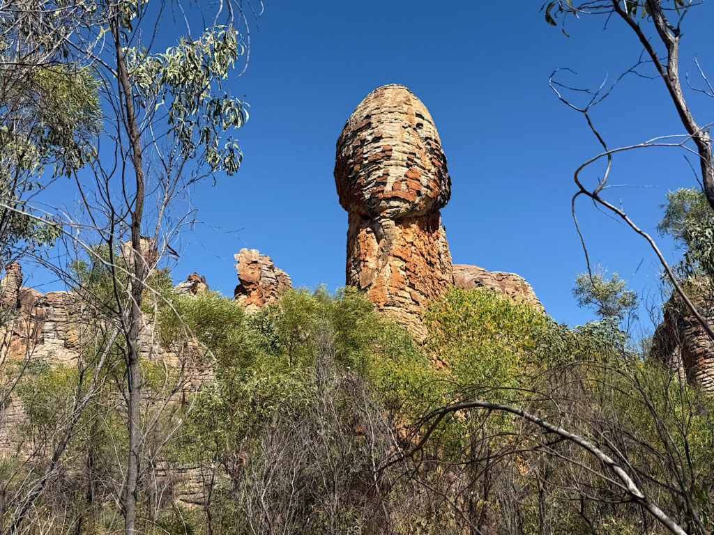
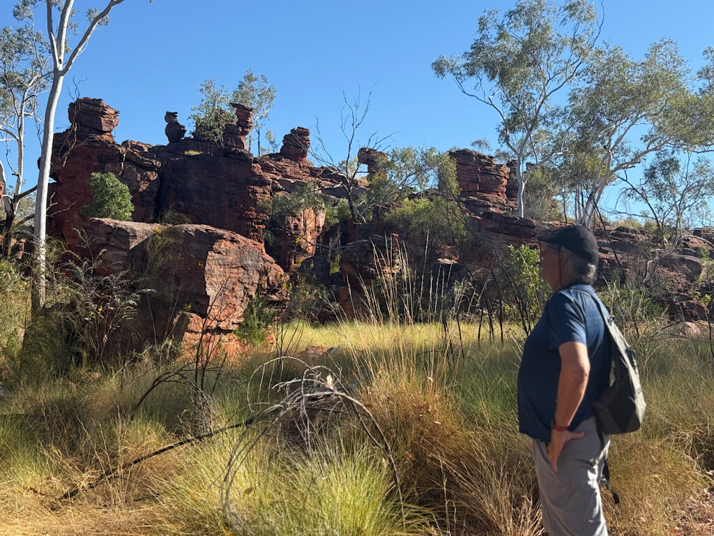
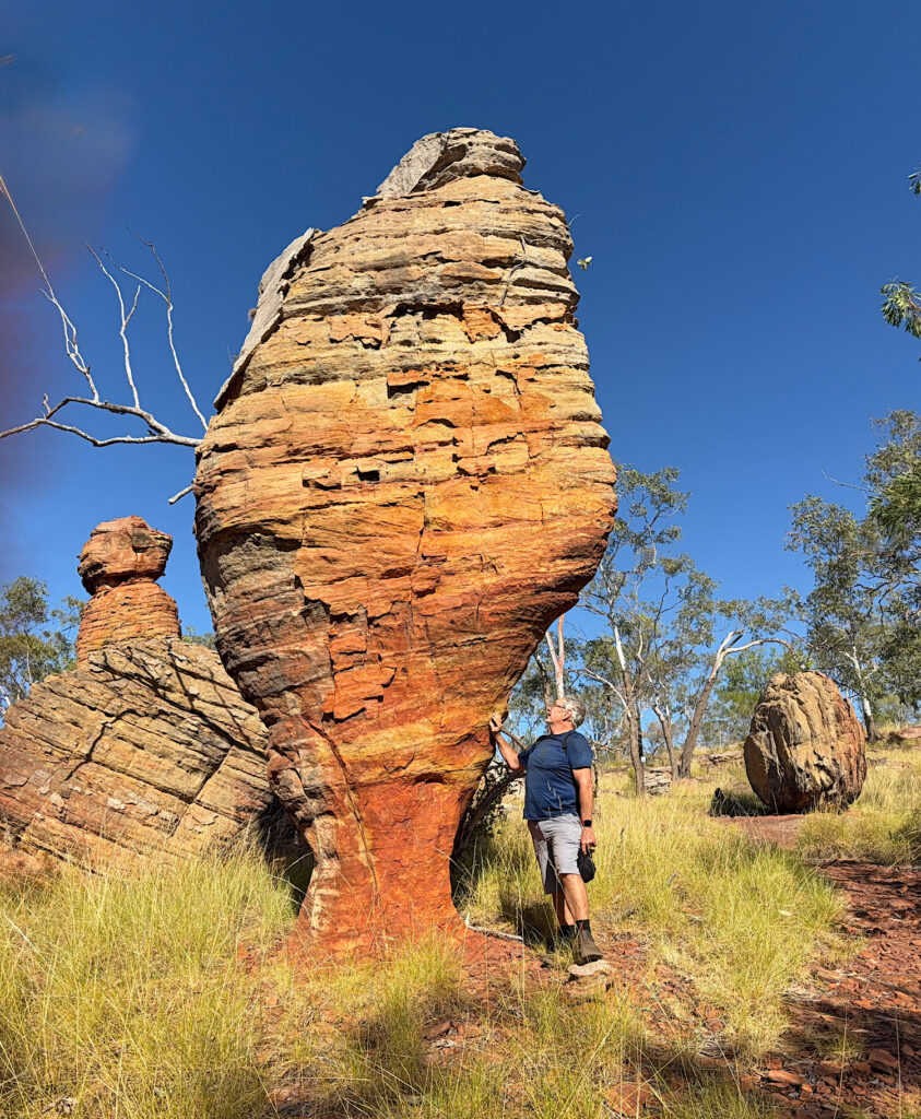
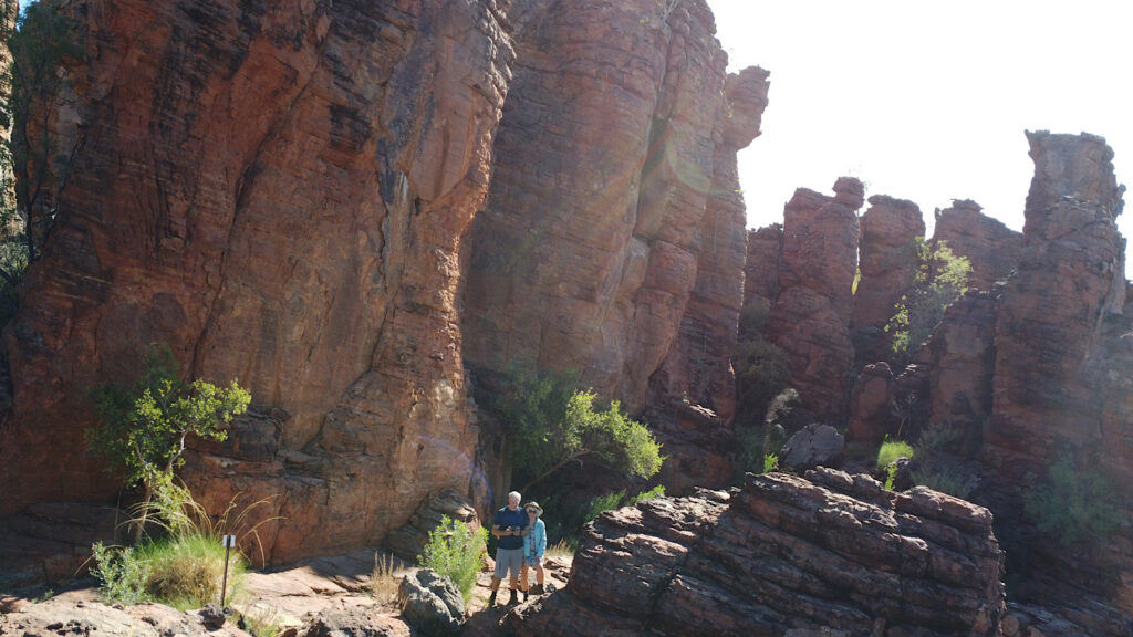
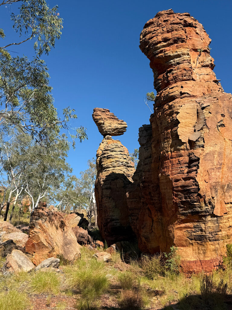
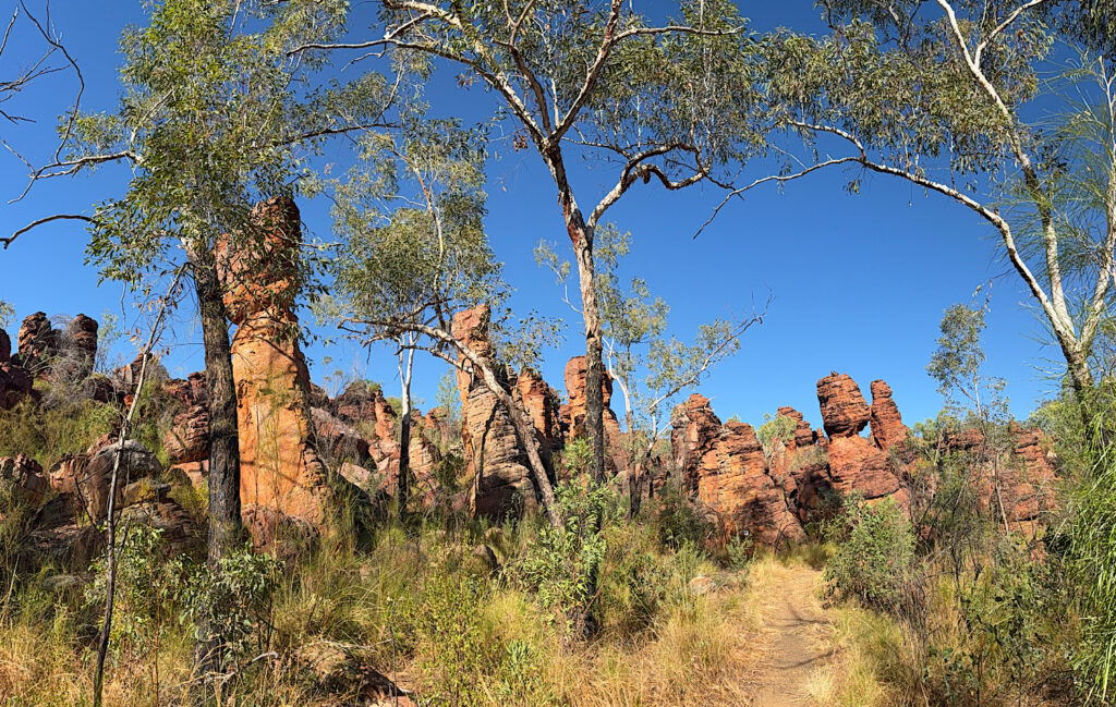
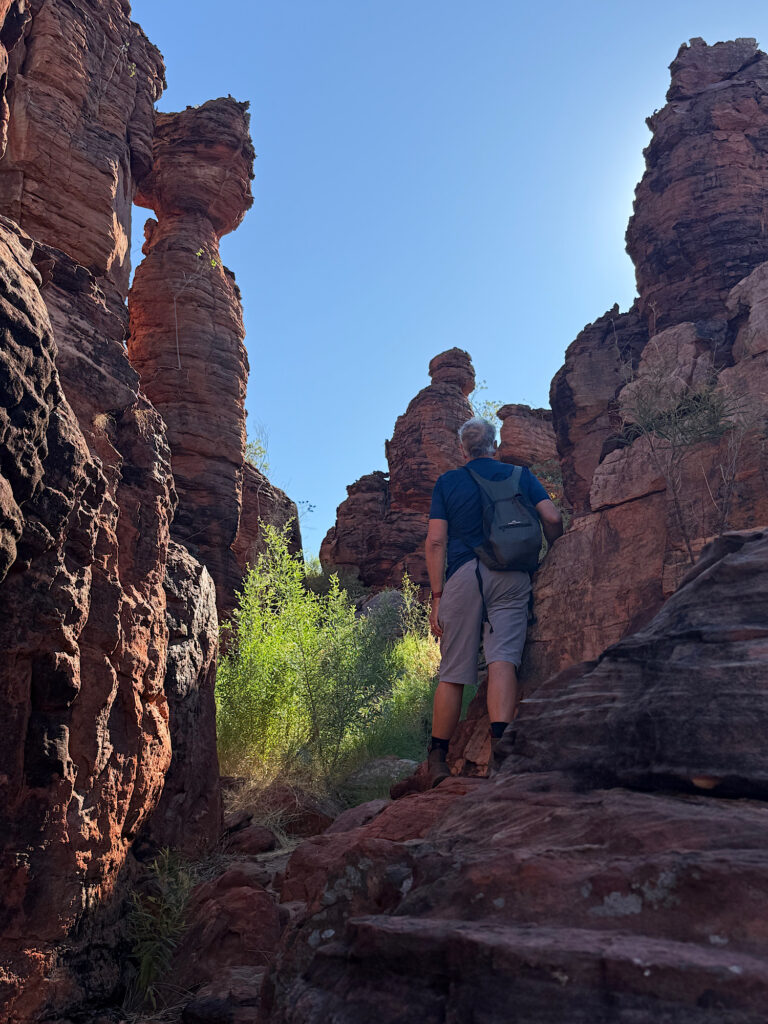
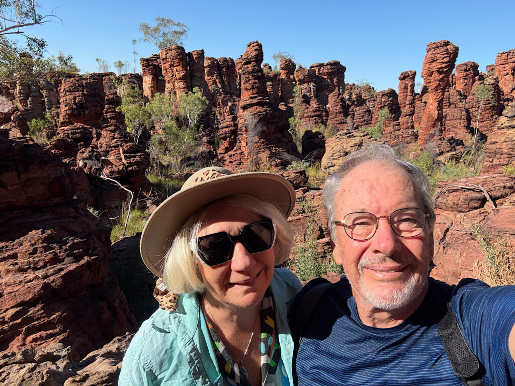
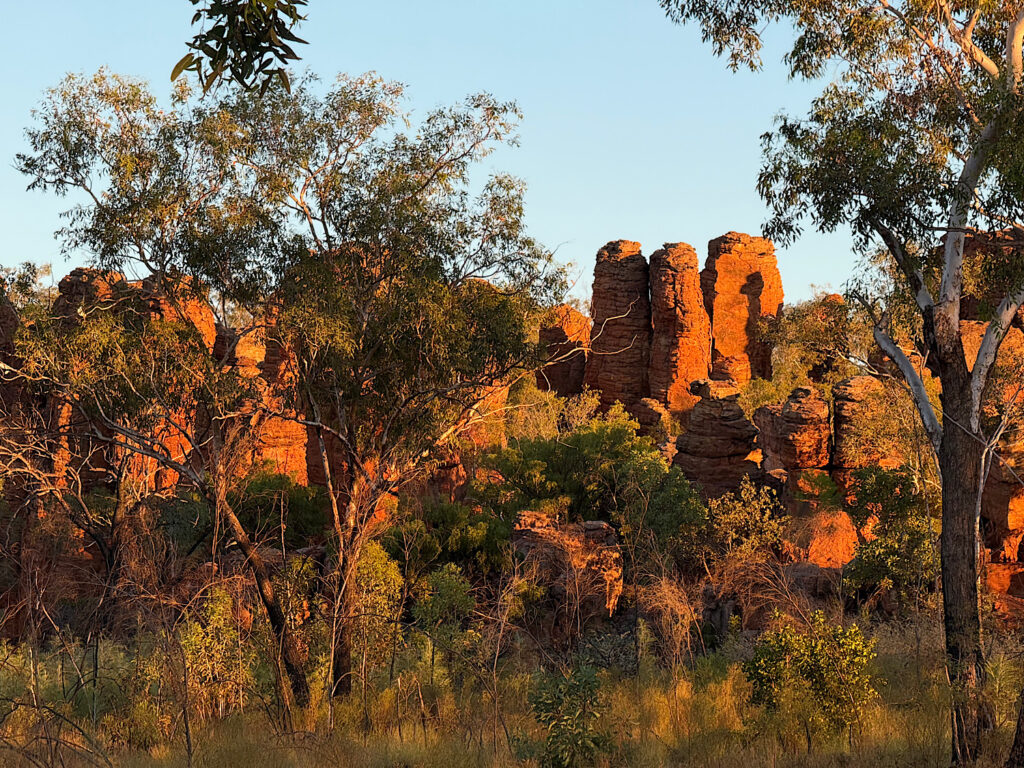
This explains better than I could how the land formations came about.To enter the Western Lost City we unlocked the gate and signed in. It’s a 30km drive into the City – it took us about an hour and a half, including a couple of stops on the way. Most of the track, which was just two wheel tracks, was OK, but there were some rough, rocky patches and washouts to negotiate and a couple of challenging water crossings.At the Ranger Station we picked up a self-guided information sheet to the drive. This lake always has water and is a popular bird watching spot. There are buffaloes in the park too that come to drink here.As the formations came into view we were stunned. I’d seen photos of what to expect, but none did them justice. It was quite spectacular.The extent of the formations, as well as the limits in width were interesting. The arch from the photo above.Why only here? Why so narrow a band? Questions, questions!The road took us alongside the formations for about a kilometre.Interesting.How do those smaller rocks on top get weathered like that? When will they fall?They look so old – and they are.This formation reminded me of the mushroom I found on the Gibb River Rd – the Shaggy Mane Mushroom or Podaxis pistillaris – just a bit bigger.Is that the Empress overlooking all who come here?
Saturday
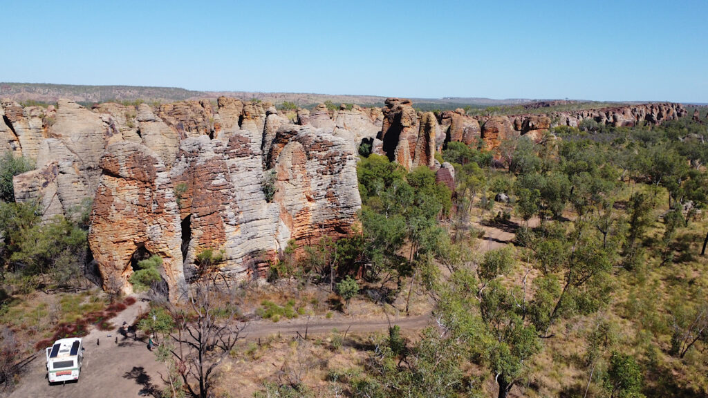
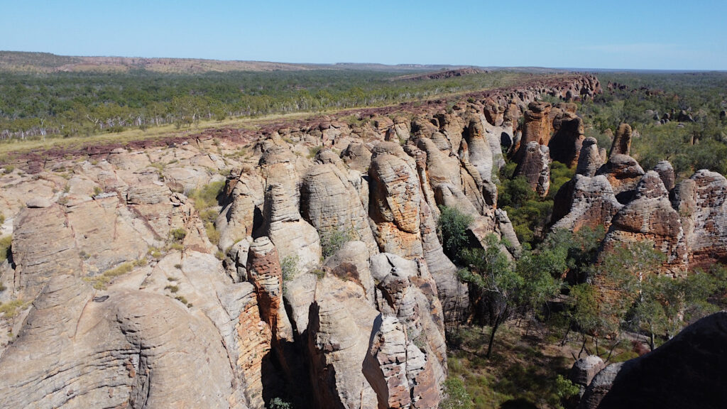
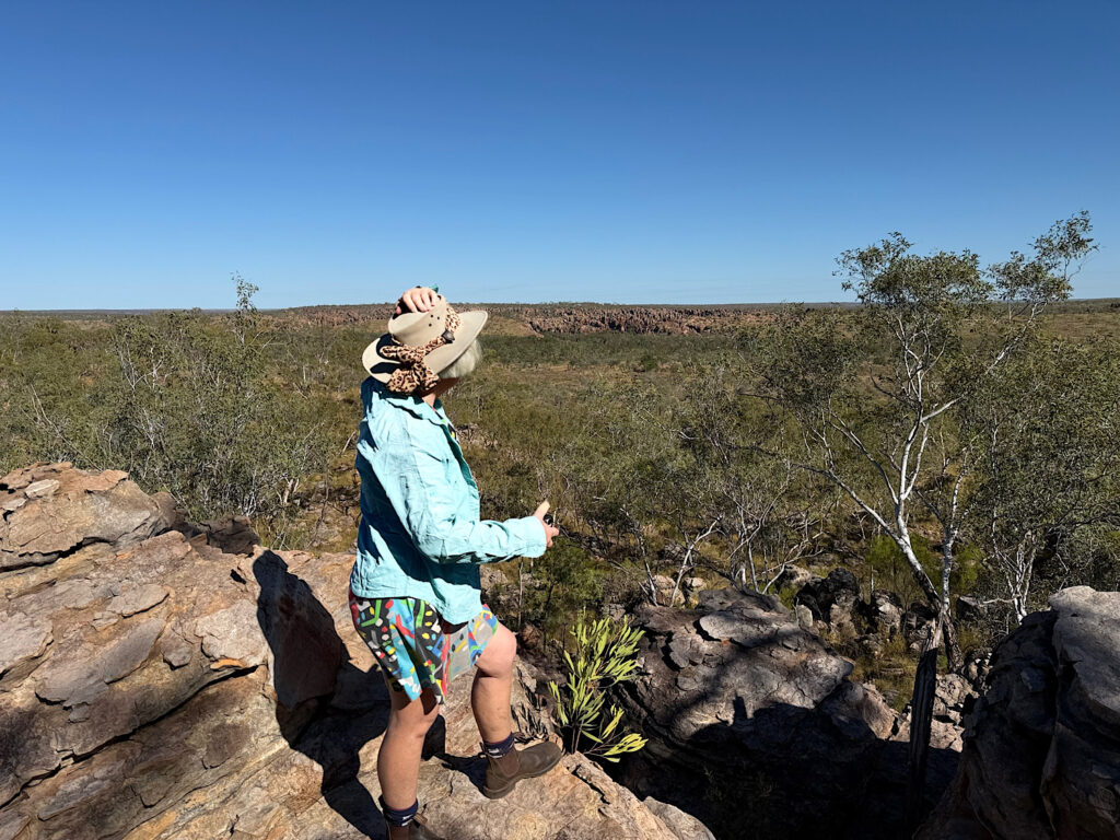
We set out early for the Southern Lost City to commence the 2.5 km walk winding through its otherworldly rock formations before it got too hot. We knew we’d linger often, and we did —capturing the intricate shapes and soaking in the ancient, sculptural landscape, preserving it for our memories. I hope you, too, enjoy some of the photos we took.
Sunday
Sadly we leave Limmen National Park today. But not before a photograph of sunrise on the Southern Lost City.
Goodbye Limmen. That was truly an outstanding experience. What an amazing country we live in!
The famous beehive domes of the Bungle Bungle Range are found in the East Kimberley in the UNESCO World Heritage listed Purnululu National Park. There’s some conjecture as to where the name Bungle Bungle came from, but consensus seems to be a derivative of the term “bundle bundle” referring to a local grass that grows in clumps. Purnululu is the local indigenous term for sandhills.
Friday
The road into Purnululu is infamous for its difficulty. A sign at the start warns that it’s suitable only for high-clearance 4-wheel drives. It is a 53 km (33 mile) drive to the Ranger Station, and the sign advises allowing 2 to 3 hours. We both agreed it was a pretty bad road with relentless corrugations and many water crossings — one of them quite deep and rocky requiring careful route-picking. Despite that, we made it in about 1.5 hours, and counted ourselves lucky.
After setting up camp at Kurrajong campground ready to do the northern hikes in the Park tomorrow, we drove back to Kungkalanayi, the indigenous term for ‘lookout’, and watched the sun set over the Bungle Bungle Range.Steve, enjoying the sunset as he sits on his rock amongst the spinifex.
Saturday
Today’s goal is to complete all the hikes in the northern section of the park. First is the 4.4km Grade 3 hike to Homestead Valley.
A lovely hike amongst the livistona palms, acacias and grevillias.This is our first experience walking amongst the amazing rock formations of the Bungle Bungle Range. The path followed a dry, stony creek bed to emerge at the top of a valley.
Echidna Chasm, our next hike, is best viewed around the middle of the day when the sun is overhead lighting up the amazing chasm walls.
Approaching the chasm.The cleft is very narrow – the walls are conglomerate rock.The sunshine has now entered the main part of the chasm.The colours were outstanding.What a great experience!
For our final hike today we’ll do the Grade 4, 4.4km Mini Palms Trail. This hike followed the escarpment before steep slopes, narrow edges and large boulders to climb under, over or squeeze between brought us to two viewing platforms.
Sunday
We moved camp this morning to Walardi, where we’ll be able to more easily access the southern hikes. This is where we first see the striped beehive domes that make Purnululu famous – and they’re every bit as incredible as we’d hoped. These ancient formations began taking shape over 350 million years ago, when rivers laid down layers of sandstone and conglomerate. Over the ages, wind, rain, and erosion sculpted them into the striking shapes we see today. The distinctive orange and dark grey bands come from differences in mineral content and moisture-loving bacteria, giving the domes their beautiful, banded beehive look.
All the hikes here start from the Piccaninny Trailhead and follow the course of Piccaninny Creek. We decided to head up the creek to Whipsnake Gorge, then explore the side tracks on our way back, covering a total of 13km. Although the creek wasn’t flowing, it held large, still pools that were sometimes tricky to skirt around. The trail itself was mostly soft sand, with stretches of river stones underfoot, and at one point, an extraordinary section of solid rock broken longitudinally with narrow, parallel clefts — the result of centuries of weathering. It made for a surprisingly varied and fascinating walk.
The trail followed the creek as it wound its way past those amazing domes.This section of the riverbed surprised me, having never seen granite laid down and weathered like this. A view along one of the clefts in the granite river bed.Such a beautiful hike.A natural window eroded through one of the domes perfectly frames scenic views of the Bungle Bungle Range.Cathedral Gorge is a breathtaking natural amphitheatre, carved from red rock over millions of years by the persistent force of water. During the wet season, a waterfall spills from the gorge’s roof into a now tranquil pool at its heart. This vast, circular cavern is famed for its remarkable acoustics. We were privileged to experience it as the haunting tones of a didgeridoo, played by an Indigenous musician, echoed through the ancient walls.
Monday
We’re leaving Purnululu today but not before we experience this amazing place from the air. Would you like to see my hundreds of photos – no, really. Well here’s just a few. Stills don’t do the flight or the National Park justice. On Tracks and Horizons YouTube channel you’ll find a video which brings it to life.
No doors to hold us in, but no doors to impede the view either. Just Steve and I and our pilot on our flight.The variety of different land formations stunned us. What we see from the ground is such a small fraction of the Park. Different formations again. And look at all those gorges – we only walked into a few gorges and were blown away by the vistas, rock formations, pools, etc. There must be hundreds more that are equally amazing.The beehive domes – fading off into the distance.Beehive domes from on top.
Completing our land exploration of the Kimberley here was an awe-inspiring finale to an epic Outback journey.
To say I’m excited to be on the Gibb River Road (GRR) is an understatement. I have a long history of planning this adventure only to be thwarted. Not this time!
The Gibb is a track constructed in the 1960s to transport cattle. It stretches from Derby in the west to Wyndham in the gulf of Carpentaria. Due to the stunning scenery and gorges it passes through it soon became an adventure drive for the keen 4×4 traveller looking for a challenge. And here we are!
A bit confusing, but it means the main track is open to us all the way to the end.
Monday – Birdwood Downs
A toast was called for!Our first campsite on the GRR is Birdwood Downs, a large pastoral station that offers camping, amenities and a shop that sells, amongst other things, their own beef, ready cryovacced for the traveller.
Tuesday – Friday: Lennard River
Ah! That’s upset our plans! It rained about a week ago; enough to close large stretches of the GRR. While the main road has reopened, the side tracks to some spots, such as Windjana Gorge and Tunnel Creek, have yet to dry out. But the ongoing promise from the Council is “could be tomorrow”. So, we stayed for 4 nights, finally leaving Saturday morning with the report that it would be “reviewed on Monday”. Oh well, I do like to have a reason to revisit an area.However all was not lost. This was our campsite on the banks of the Lennard River while we waited. We became good friends with the other two campers here with us.And once or twice a day we had a soak in the crystal clear, refreshing river. Your interesting factoid for today: this is Podaxis pistillaris, also known as the Shaggy Mane Mushroom. It’s a rare find though not an endangered species. It’s native to the arid regions of Western Australia, only making an appearance after heavy rain. We spotted this little character right beside our camp.
Saturday, Sunday: Mt Hart Station
Leaving Lennard River we entered Wunaamin Miliwundi Ranges (King Leopold Ranges) and stopped at the Apex River for lunch, then decided it was a great place to spend the night before the trip into Mt Hart tomorrow.Mt Hart was a cattle station for about 80 years last century, though all Station owners struggled to make a living from it. In 2000 it was reclassified as a conservation park and since 2022 new owners are developing it as a tourist destination. The 50km road in from the GRR has been badly broken up after the recent rain and there are still many water crossings to negotiate on the drive in. It is a beautiful property offering everything from camping and glamping to lodge-style accommodation. There’s a bar and restaurant onsite and adventurous visitors can take a helicopter ride or do a 4×4 tour. At the moment there are two gorges open that you can drive to – we visited Dudungarri mindi, pictured above, and Dawungumen mindi.Dawungumen mindi was a short hike from the carpark over huge boulders. The Barker River flows through the gorge and the rocks made for great rapids and pools where we spent several hours relaxing in our own private rock pool.Challenging to get to, but worth every difficult step once there.This fellow was snapped warming up on the rocks after a chilly swim. It’s a variety of Monitor Lizard; this one is about 60cm (2ft) long.
Leaving Mt Hart we camped at Dog-chain Creek, again in near solitude.
Monday – Silent Grove and Bell Gorge (Dalmanyi)
This morning the Gibb took us through the Wunaamin Miliwundi range with its striking cliffs and rock faces, occasional water crossings and beautiful trees, which was a delightful way to start the day.
The campground is at Silent Grove, about 20km off the Gibb, with Bell Gorge another 10km drive beyond that, followed by a hike. The road had only reopened a couple of days earlier, still scattered with long muddy stretches and water crossings through fast-flowing, though shallow, creeks. All part of the adventure for us — though, watching the owners of the big vehicle-and-caravan setups tackling the deeper crossings, I got the feeling they didn’t enjoy it quite as much as we did.
While the hike is only 3.5km to the bottom of the Falls the first section is Grade 4 taking you on a boulder strewn track to the top of the Falls, and the last section, a Grade 5, takes you to the base of the Falls. Lots of warnings accompanied this hike.But WOW — what a view, what a waterfall! Five tiers of it, spilling down the cliffs like something straight out of a postcard. Up the top there’s a great pool for a swim, and the only way to start the hike to the bottom is to dive in and swim across it. Not a bad way to kick off a walk, if you ask me.National Parks’ sense of humour. The hike descends straight over that cliff edge – I think the pole with the upward arrow indicates where you’ll be going if you misstep your first step.Made it! We spent a couple of hours here swimming and relaxing. So beautiful.Steve – time to head back.Not my favourite hiking surface, or incline!
Tuesday – Adcock Gorge, Galvans Gorge, Mount Barnett Station
A gorgeous day full of gorges ;-). Adcock Gorge is about 70km further along the Gibb, then a 5km side road, before a tricky, rocky but short, hike in to the Gorge.
Adcock Gorge. This deep green pool with it’s beautiful waterfall and overhanging ledges was very picturesque.We both enjoyed a lovely swim and a shower under the waterfall at Adcock Gorge, before getting ready to head back. That’s when near-disaster struck!I like to tell folks that my hero was wrestling a crocodile that had me in its jaws… but truth is, it was a slip, a loss of balance, then an absolutely world-class shallow dive back into the pool, not quite clearing the protruding rocks. It was impressive and anything less would not have ended quite so well.Moving on to Galvans Gorge the short walk in initially took us past this pretty waterlilly pond, before the inevitable scramble over rocks and boulders.Galvans Gorge, another stunning gorge. I loved the Boab tree taking pride of place at the top of the falls – probably ranking as one of the most photographed boabs on the Gibb.
Tonight we’ll camp at Mount Barnett Station. There’s a lovely big lagoon here with sandy beaches, right beside the campsite – no boulders! Top swimming spot.
Wednesday – Manning Gorge
Manning Gorge, on the Barnett River in Mount Barnett Station, is one of the better known gorges. The large campsite caters for lots of campers as well as tour buses. It can get very crowded in the ‘season’.
The warning sign at the beginning of the hike is explicit! This is a difficult walk and … “There is no-one within 300km equipped for rescue operations …” OK!! You’ll note the hike starts (and ends) at the lagoon, which is deep water in the middle. Plastic tubs, halved, are provided to put your hiking gear in to stay dry, then you swim across to the other side pushing your tub to begin the hike. As we left, at 8am, the swim was a chilly wake-up, but on the way back, after a hot walk, it was heaven!The hike was up to WA standards – lots of ups and downs over boulders and stones, the path gnarly in parts and needing a fair degree of physical fitness to ascend and descend the big boulders.Finally arriving at the river this is the view to the left, where lots of exploring could be done … not saying it was.And to the right — this is what we’d all come to see. No other tourists around when I snapped this photo, though people drift in and out. Luckily, it wasn’t busy while we were here. The swimming was absolutely magic — cool, crystal-clear water, the perfect reward after that hot, sweaty, and energetic hike. We swam to the rocks straight ahead – the nearest resting place to the waterfall. I couldn’t resist trying to swim under the waterfall, but the force of the flow and the swirling current quickly pushed me back. It was so invigorating, and exactly what you hope for in a spot like this.A memory etched on my brain for posterity.And the classic photo!Camped beside a huge multi-stemmed Boab at Manning Gorge campground.As we left Mount Barnett we stopped at the Roadhouse to fill our tanks with water and diesel (different tanks) (diesel – $2.93/L!!!) and buy an ice cream each for the road.
Thursday, Friday – Hann River
The Hann River here was only thigh deep in parts, but the current was really strong. Soaking in this chilly, crystal-clear spa felt like the best full-body massage.Our ideal campsite, just beside the river. Hann RiverCouldn’t help myself – it’s such a good campsite. Wish we could have stayed more than two nights.
Saturday – Gibb River
Praise be to the Gods of the Graders! Before this glorious sight appeared before our weary eyes (please let it be real, not a mirage!), the road was a bone-rattling mass of corrugations. If you look to the left of the photo, you’ll see where the grader hasn’t reached yet — those ridges are brutal. Even where it’s passed, it’s really only skimmed the top off them. But we’ll take whatever relief we can get!And here it is — the Gibb River itself, the namesake of this famous track. Ironically though, the Gibb River Road doesn’t actually cross the Gibb River. (Go figure.) Naturally, we couldn’t pass through without at least getting wet in it. We turned off onto the Kalumburu Road, which does cross the Gibb River, and set up camp — another beautiful, crystal-clear stream winding its way beneath the melaleucas and river red gums. Magic spot.Needless to say we did have a lovely swim here, then enjoyed a chilled beverage as the sun set.
Sunday – Durack River
Things are changing! We’re travelling through hilly countryside now, with vistas across vast grassland plains. And, happily, the steeper sections of the road are sealed – but not for very far! Those corrugations are still with us.Ellenbrae is a working cattle station. The grounds are very attractive – they remind you you’re in the tropics with their lush gardens of tropical flowering plants, and bananas and mango trees that provide shade and fruit. They run about 600 head of cattle that they sell only when cattle prices are high. The cost of labour to muster and then transport the cattle from this remote location has to be factored in.We actually came here for a Devonshire tea – yes, true! Ellenbrae is famous amongst travellers for their fresh scones, jam and cream. Last year, during the 6 months of the season they’re open, they sold over 21,000 scones.A little further along the GRR we crossed the Durack River – a frequent point for flooding that closes the road. The water across the road is still pretty deep, but having a firm base we crossed without incident. A road crew was working at the turnoff to the Durack River free camp, which is little more than a narrow track winding through grass and rocks. I suspect most travellers assumed the campsite was closed as only two of us stayed here. No swimming here; this river’s a haunt for crocodiles.Our first campfire for the trip – we’ve shared others’ fires but this is our first.
Monday – Pentecost River Crossing
Exciting day today! Today we cross the Pentecost River. Everyone who does the GRR has a photo of their crossing. But first we have some pretty badly corrugated road to traverse …
And just to prove my point! No, not our’s thankfully; just a fellow traveller we stopped to assist.The Cockburn Range comes into sight. A pretty stunning range with its ridges, cliffs and mesas.Another lovely view of the Cockburn Range. The yellow-flowering trees are young kapok trees. Some of you may remember when kapok stuffed pillows and mattresses were used.The Pentecost flood plain. This is it! Crossing the Pentecost River. Stills don’t give you much of an idea of what it’s like. Please watch the Tracks and Horizons YouTube channel to view us crossing.
There are campsites scattered all along the Pentecost River, and we found ourselves a great spot right on the bank just above the water’s edge, joining dozens of others doing the same. We’re only staying the one night, but it seems many settle in here for a while — the barramundi fishing is said to be promising. That said, it’s very much crocodile country. A 5-metre croc was seen lurking on the far bank for several days, so no swim today.
Tuesday, Wednesday – El Questro
El Questro’s story began back in 1903 as a 1-million-acre cattle station. Like so many out here in the Kimberley, it battled tough conditions and isolation, and few owners managed to make it pay. In 1991, the owners opened the gates to tourists, offering everything from bush camping to outback luxury, and it’s been a popular stop on the Gibb River Road ever since. Since then the property has changed hands a few times and was even foreign-owned for a while. Then in 2021, the G’day Group took over and struck a new deal with the traditional owners and the WA government. The pastoral lease — which had legally required them to run cattle — was converted into a Reserve, along with a parcel of Freehold land. That Freehold was leased back to G’day Group so they could keep running the tourism venture, ensuring this remarkable place stays open for travellers keen to experience the Kimberley’s rugged beauty. The Reserve is now being managed by the traditional owners. A win-win situation for all involved.
Activities at El Questro include, hiking, swimming at select gorges that are croc-free, four-wheel-drive tracks to scenic lookouts, helicopter rides, tours, horse riding, etc.
Amalia Gorge was the first activity we chose to do. For those not in the know – fresh water crocodiles may nip you if you annoy them, but won’t eat you; whereas salt water crocodiles will not hesitate to eat you. And their names are misleading – both crocs can live in both saltwater and freshwater.It’s not that we enjoy tackling Grade 5 hikes — we really don’t — but in WA, it seems like anything less than a 4 or 5 isn’t worth marking on the map. And this one was a tough slog! The photos above and below give you a bit of an idea, though they miss the hairiest part: a narrow, uneven ledge where we edged along, clinging to a chain bolted into the rock because the cliff face offered nothing else to hold onto. Heart-in-mouth stuff.This, though, was the perfect reward. Happy me, not giving a thought to the return hike.That afternoon we set off on the 4×4 track to Saddleback Lookout. I took this photo along the way, though it barely hints at the drama of the drive or the spectacular view waiting at the top. The track begins with a solid water crossing, then immediately starts to climb — a steep, narrow, rocky trail that winds sharply through rugged country. Low Range, first gear was the only way up (and down), with loose stones, washouts and dropoffs to oblivion alongside the track keeping us alert. As we neared the summit, the landscape opened up, and from the top, we were treated to breathtaking, uninterrupted 360° views of the surrounding ranges and valleys.
Tonight we dressed up and went to the El Questro restaurant for dinner. Quite the treat!
First thing this morning we headed for Zebedee Springs. These hot springs occur because of a fault line deep inside the earth providing a continuous supply of water heated to 28° to 32°C all year.
An easy 300m walk from the carpark through savanna woodland and livistona palms brought us to the hot springs. Zebedee Springs are only open between 7 and midday. The afternoons are for the exclusive use of the guests in the Homestead who are paying several thousand dollars a night for the privilege.I found myself a delightful, warm, massaging waterfall to relax in.Steve found a rock-lined pool to float in while enjoying the view above.Steve’s view – the magnificent livistona palms.
After lunch and a wander around the Station, we made our way up to Pigeon Hole Lookout for sunset. I’ve no idea how it got the name, but it’s a 12km drive from the campsite along rough, rocky tracks with several water crossings — one of them was particularly long, deep and with a base of big, loose rocks. The final climb to the lookout wasn’t as hair raising as last night’s trek up to Saddleback, but the narrow, winding track still had us quietly hoping no one was coming the other way.
The spectacular view of the Pentecost River from Pigeon Hole Lookout.The Pentecost as the sun set over the ranges.The ‘other’ side of the lookout.
Thursday: Our last day on the Gibb.
The Gibb has been a road trip that just keeps giving. Even on our last day we’re going to yet another beautiful gorge – Emma Gorge. Emma Gorge is a few kilometres further along the Gibb and is a part of the El Questro freehold lease offering more accommodation, though not camping. We had a coffee here at their lovely bar/restaurant before setting out on the 3+km hike to the Gorge. By now I hope you’re attuned to every hike up here in the north, regardless of length, being a challenge and, in keeping with the plan, Emma Gorge is classified as a Grade 4 hike.
The track on the way to Emma GorgeNote how the cliff walls of the gorge continue to narrow as we walk in.The gorge comes to an end here, with a waterfall tumbling into a serene, sheltered pool. The water was the coldest we’d felt so far — the kind that takes your breath away and makes you hesitate before going under.Swimming under the waterfall was, as usual, an exhilarating experience. The pool at Emma Gorge. Tucked away behind the rocky outcrop on the right was a tiny artesian spring, its warm water heating a little rock pool. A delight at the time, even though it made the swim back to shore all the more chilly.
One feature of the Kimberley which I didn’t expect was the sheer number of Boab trees (Adansonia gregorii). This particular species is endemic to the Kimberley region of Western Australia and into the Northern Territory. Yes, I expected to see a few, but there are a lot of boabs spread over the whole region. At El Questro they line every road and will be wonderful shade trees as they mature. Boabs are surprisingly useful — their iron-rich leaves can be eaten like spinach, and the nut contains a sherbet-like pulp. Their swollen trunks store water, with some said to hold up to 100,000 litres — a clever adaptation.
Two boabs demonstrate their individuality in trunk design. The end of the Gibb River Road. The official sign, which has no personality, seen in background.
Wow — what an adventure this has been. We set out with uncertain expectations, a few quiet fears about what might go wrong, and not much idea of what lay ahead. But those worries faded quickly as our confidence in both the vehicle and ourselves grew. In their place came awe. Moment after moment took our breath away, and that sense of wonder never left us. If anything, it built with each day, filling us with excitement and anticipation right through to the very end.
I found the following paragraph which describes our journey accurately. I only wish I had written it.
The Gibb River Road is more than just a track through the Kimberley — it’s a journey through some of Australia’s most ancient, untamed, and soul-stirring country. It’s a place where red dirt clings to your boots, waterfalls tumble into crystal-clear pools, and the night skies stretch endlessly overhead, heavy with stars. The road demands a little grit, a sense of humour, and a willingness to slow down and soak in the unexpected. It weaves through gorges, across rivers, and past landscapes so vast and varied they defy description. Every bump, every dusty kilometre, every water crossing is part of a story you’ll carry long after the tyres hit bitumen again. It’s a trip that reminds you how small you are — and how lucky — to stand in a land this wild, this beautiful, and this enduring.
After restocking the pantry and refuelling in Halls Creek, we briefly joined the steady stream of Grey Nomads making their way around the Big Lap on Highway 1 as we headed towards Broome. After so much time in solitude, it may take a little adjusting to reacquaint ourselves with polite company. Rain is forecast – from here across to the coast and into the region the Gibb River Road traverses. We’ve got a few days yet before we hit the unsealed roads so we’re remaining optimistic.
On Sunday night, we camped at Mary Pool, a popular free camp set on the banks of the Mary River. It’s a scenic and peaceful spot, though we made an early departure the following morning. As it turned out, our timing was fortunate — Council workers advised remaining campers to vacate ahead of the approaching rain.
A shortish drive further on and we came across Ngumban Cliffs free camp. Wow! So unexpected after travelling through flat countryside, and so beautiful.Lots of caravans already here but, being easily manoeuvrable, we got a prime spot – see us, top right.Tuesday night’s free camp was beside an enormous Boab, easily the biggest I’ve ever laid eyes on — an impressive natural landmark in its own right. Wow!
Wednesday, Thursday
And here it is! The Indian Ocean. 30 days from Pacific Ocean to Indian Ocean.Yes we’re in Broome and we’re doing what one does in Broome – we’ve driven onto Cable Beach to watch the sun set over the ocean, and celebrate a great trip from coast to coast.It’s fun watching the camel train pass by as the sun sets.It wasn’t ALL drinking in Broome, but Matsos brewery is one you can’t go past.
Friday, Saturday
The Dampier Peninsula stretches north of Broome and is highly regarded for its pristine beaches, relative isolation and the pearling industry. The pearl industry put Broome on the map in the 1880’s. By 1914 Broome was providing 80% of the world’s pearl shell and still today is highly regarded for producing some of the finest South Sea pearls.
We’re spending two nights at Pender Bay Escape on the Peninsula. While the road to the Cape is sealed, once we turned off to our destination we had 40 km of unsealed road, which the recent rain hadn’t improved. We drove through over 100 of these muddy puddles of various sizes and depths.And this is where we ended up. Hard to complain!Long, peaceful walks along the beach, with the dramatic, unusual cliffs rising beside us, made for a truly memorable experience.Caves and clefts and rock falls and amazing colours characterised the cliffs of our beach.Always a price to pay – the motorhome was filthy. Broome car wash is making a fortune!
Sunday
This is the famous D-shaped jetty at Derby. The tides here are some of the biggest in the world — up to 11.8 metres between low and high tide. We’re here at mid-tide, when the water’s absolutely flying past. It’s hard to show just how fast it’s moving, but let’s just say if you drop something in, you won’t be getting it back.Beautiful seaside sculptures in Derby.
The Tanami Road follows an old cattle droving route from the MacDonnell Ranges just north of Alice Springs, stretching north-west across the Tanami Desert for 1,035km (643mi) to meet the Great Northern Highway near Halls Creek in Western Australia. This road takes the traveller, station hands, local indigenous people travelling to their communities and massive road trains through some of the most remote country in Australia. While Federal and State governments are working on sealing the road there are still long stretches of gravel road often with bad corrugations, potholes and washouts. After passing the community of Yuendumu there is no fuel, food or water available to tourists for 760km. Should it rain the road will be closed and the traveller stays put until it opens again. Travelling these outback roads is no casual undertaking.
Monday
We plan to complete the crossing in 5 days. We’re fuelled up, water tanks full and I think I’ve got enough food for 2 or more weeks (bit of overkill there!).
All good for the moment. The skies are blue and the forecast is good.These tree-less hills covered in spinifex started the day for us.Tilmouth Well – hmmm. We try to support all the little roadhouses and small towns we pass along the way, so dropped in here for a snack. The area in front of the shop was full of litter, the toilets were filthy and the snacks were all deep-fried, ready-made food. Not easy to give support in these cases.
The road so far is sealed – easy driving. We’ll cover about 300km today – a big day for us as we like to stop to stretch our legs and swap drivers, then have plenty of time to enjoy the destination.
Tonight’s camp is a flat area beside a windmill. Luckily it wasn’t a windy night.We’re now in flat country and the stars stretch from horizon to horizon.
Tuesday
We’ll cover another 300 or so kilometres today, but first just 22km on from last night’s campsite is Yuendumu, an obligatory refuelling stop for us if we’re to make the distance to Halls Creek.
Despite arriving half an hour after opening time, there wasn’t a soul in sight… and the self-serve fuel pump wasn’t working. Not a good sign. About an hour later, the storekeeper finally appeared and casually explained they were running low on fuel and waiting for the tanker to arrive. For a brief, uneasy moment, we imagined being stuck here for days. Then, with a shrug, he pulled out a key, pressed a few buttons, and got the pump going. Relief. Our long-range tanks hold 145 litres — and we made sure to fill them to the brim. With normal motoring (ie not 4×4) that should take us about 1000 km – but, there will be 4×4 driving happening.
Relieved to have fuel in the tank, we wandered into the grocery store — and couldn’t believe our eyes. There were stacks of eggs, when just days earlier there hadn’t been a single one to be found in the entire town of Alice Springs! To our surprise, it turned out to be a remarkably well-stocked little store, with everything from fresh fruit and vegetables to televisions, hardware… even tutus. Out here, you really do learn to expect the unexpected.
The sealed road disappeared all too soon. The bulldust cloud ahead of us is from a slow-moving road train, but not slow enough to overtake, particularly when you have no visibility once directly behind it. The road trains make a mess of the roads – we soon had big corrugations which forced us to drive slowly.Travelling slowly allowed us to enjoy the countryside even more. I know it’s hard to believe this is the desert, but the green you see isn’t grass, it’s spinifex. And just look at all those termite mounds – kilometre after kilometre of them.Catching up with our road train when he’d stopped to check his rig we had a bit of a chat – as one does when you’re about the only people you’ll see all day. He’s carrying concrete powder to a gold mine at The Granites. He’ll deliver today, drive back to Alice tomorrow and return with another load the next day. He told us there are 3 road trains doing this constantly – that’s a lotta concrete!
Tonight we camped at a roadside pullover ignominiously known as ‘Camel Toe Quarry’. There was a dam nearby, some of the prints in the dust could have been from camels, but most were cattle.
Wednesday
Big excitement today – we cross the border into Western Australia.
Sadly, neither the WA nor NT governments seemed to share our excitement about their border. The only marker was a cluster of empty bottles and a weathered, handwritten sign left behind by a traveller from who-knows-when. The border sign was leaning up against the rubbish bin. I just couldn’t believe the colours in the sky highlighting the spinifex at tonight’s campsite.
Thursday
Today’s adventure took us to Wolfe Creek Meteorite Crater — or as the exclamation goes, “that place from the horror movie”. For the record, even though the plot was loosely based on real crimes, NONE of the events in the unfortunately named Wolf Creek horror film happened here. Thankfully I haven’t seen the movie and would very much like to sleep tonight without imagining serial killers in the bushes.
Obviously NOT our Wolfe Creek! This road is sealed!!
The section of the Tanami Road we travelled today was in very poor condition. Deep potholes, washouts, thick bulldust, and heavy corrugations made for a difficult and slow drive. Even after turning onto Crater Road, the road surface remained rough and challenging.
Wolfe Creek Crater was formed approximately 120,000 years ago when a large meteorite struck the earth. It is the second-largest meteorite crater in the world, measuring 876 metres in diameter with an original depth of around 120 metres.
It is known as Kandimalal by the Jaru aboriginal people of the district. There are several creation stories explaining the crater. One describes two rainbow serpents meeting here, forming two of the local rivers. One of the serpents came out of the ground, forming the huge crater. Another Dreamtime story involves the evening star getting too close to the crescent moon and burning up, falling to earth, creating an enormous explosion and flash followed by a dust cloud.
The crater sides are steep, rocky and uneven. A 4km walking track around the rim couldn’t be ignored so, despite the terrain, we completed the circuit and took in the remarkable views of this ancient geological feature. This is indicative of the track, and yes, I did grizzle about it a lot. And while I’m still grizzling, let me assure you that spinifex does penetrate hiking pants and feels like needles digging into your skin.But the flowering spinifex is just so pretty. When the wind blows it ripples like water on a lake.
Friday
Our last day on the Tanami. The corrugations, bulldust, washouts, etc, etc continued for a while longer before the lovely smooth sealed road once again appeared. This is cattle country. Travelling these outback roads there is usually a lot of road kill, mostly kangaroos. Interestingly we’ve seen very little road kill and when we do see any it’s mostly cattle – the properties aren’t fenced.
Between some States and some areas of Australia there are quarantine borders to prevent the spread of agricultural pests. The only ‘contraband’ food items remaining in our pantry were onions and garlic. The regulations with these are that they must be peeled, hence my onions and garlic are now peeled ready for quick meal prep.
Meeting the Great Northern Highway is the end of the Tanami, but it really wasn’t a photo opportunity! We drove on to Halls Creek where we refuelled, filled our water tank, and bought some fruit and vegetables. There’s no where to stay in Halls Creek so we headed out of town to Sawpit Gorge.
Such a pretty gorge with a deliciously cool creek to take a swim. Totally relaxed after the long, dusty Tanami. Our campsite at Sawpit Gorge. Believe it or not another free campsite we had all to ourselves for two nights.
And so our Tanami adventure comes to an end. In summary, it’s a long, often lonely journey with few distractions along the way. The beauty out here isn’t in flashy landmarks — it’s in the remoteness, the ever-so-subtle shifts in the landscape and colours of the desert, and those endless horizons that invite you to never stop exploring. It’s a road that reminds you how big this country really is, and how small you are within it.
Three days in Alice Springs isn’t nearly enough particularly when we really needed to clean the motorhome, restock, refuel, carry out some repairs, and finally relax. Alice is a lovely town. Its isolation means everything you might need is conveniently clustered within a small area — hardware stores, hiking and camping supplies, well-stocked supermarkets (though eggs were in short supply!), and mechanical services. We even found two restaurants that turned out to be gems – an Indonesian and a Vietnamese. Thankfully we’ve had no mechanical issues, but will need to replace the filter on the drinking water tap.
Alice Springs from Anzac Hill, looking over the town to the West MacDonnell Ranges. For those not in the know, the flags are the Australian flag, the Northern Territory flag, the Aboriginal flag and the Torres Strait Islander flag.
Thursday, Friday, Saturday
Palm Valley, another highly recommended destination, is 123km SW of Alice in Finke National Park. To get there you travel through Hermannsburg and Namatjira country. Albert Namatjira (1902–1959), an Arrernte landscape artist born in Hermannsburg, captured the breathtaking beauty of this region in his distinctive paintings.
A monument to the great artist.This is the home Albert built for his family after he was granted Australian citizenship — the first Aboriginal person to receive it. (Pause a moment to consider the irony of this.) Despite achieving significant success and international recognition as an artist, restrictions placed on Aboriginal people at the time meant the government controlled his finances, preventing him from leaving the legacy he intended for his family.Finke National Park is named after the Finke River, the oldest river in the world based on studies of its geology. Now it only runs a few times a year. Our drive into Palm Valley necessitated us driving along its very rocky bed.After settling in to camp we walked back here to do the Mpaara Walk amongst all these amazing landforms.We decided this rock looked like a grouper (the fish!)The views just kept coming. Incredible country.Back at camp, we enjoyed a cold drink while admiring the brilliant colours of the mountain as the sun set. Next morning we embarked on the 13.5km moderately hard Palm Valley and Mpulungkinya Track. It is possible to drive 4 km closer, but the road is in very poor condition and 4K just isn’t worth damaging our motorhome for.Steve doing some arty photography. Palm CreekPalm Valley is named after the rare Red Cabbage Palm, a species found nowhere else but this valley. This photo shows a young plant, while the palms in the following images are fully grown, showcasing the mature form of this unique species.I took this photo after a lot of climbing got us to the top, then the arrow just pointed down, seemingly over the cliff edge! Yikes! It was a lovely walk alongside Palm Creek, then up and over the hill and back down again to follow the creek back to the trailhead. One tricky section had me balancing on a very narrow ledge clinging to the rock face by my fingertips while Steve put pressure on my back to prevent me falling. What one does, hey!
Next morning we headed back to Alice Springs to restock and prepare to head north.
”The Plenty” is a classic 500km outback drive with a long, colourful history. It started out as a rough track connecting Northern Territory cattle stations to western Queensland and eventually became a bit of a rite of passage for 4WD travellers. It was once infamous for its brutal corrugations and bulldust holes big enough to swallow a caravan, but these days those horror stories are mostly in the past. The road’s gradually being sealed, though there are still plenty of long, dusty stretches, with bulldust, to tackle. If you haven’t come across bulldust before, it’s a fine, powdery red dust created when vehicles break the surface of dirt roads. The dust settles back onto the track, filling dips, potholes, and ruts, making the road appear deceptively flat — until your vehicle suddenly drops into one. Hitting a deep bulldust hole at speed can cause serious damage. Visibility’s another issue. When an oncoming vehicle stirs it up, bulldust hangs thick in the air, completely obscuring your view just as the other vehicle passes — a dangerous moment if there’s more traffic coming the other way.
Despite this fearsome description we thoroughly enjoyed our drive on The Plenty. Our first stop was Tobermorey Station to refuel the vehicle ($2.85/L !!) and re-caffeinate us. The Station is a green oasis in this remote country.
Driving in to the Station this young man was leaving for a mustering job, taking his muster dogs, and puppies, with him.This gives the traveller an idea of what happens out here when it rains!Just finished our coffee and standing beside the old truck that has become the fire pit.For the next couple of hundred kilometres the gravel road was generally in good condition with only small corrugations, though one section had many bulldust ‘dips’.This caravanner wasn’t so lucky. Out here in the Outback, there’s an unspoken rule — you never leave someone stranded. He’d already been waiting over an hour by the time we came along, and apart from our friends, who we knew were about an hour behind us, not a single other vehicle came through. It took some time to get him going again, and later that evening when we found a flat patch off the track to camp only one more car came through. Moments like that remind you just how vast and isolated this country can be — and how much we still rely on each other out here.
After a very peaceful night camped just off the track and awakening to perfect blue skies, with temperatures not anticipated to rise above 26°, we headed off. Other than a massive termite mound and the beautiful Harts Range appearing, it was an uneventful drive through Mitchell grass plains to Gemtree Cattle Station.
Termite mounds are unique to northern Australia. The termites that live in this mound collect the surrounding spinifex and store it in the mound. Mound design is very complex, ensuring ventilation, humidity and heat control, and protection from predators and the heavy rains that affect the area.The Harts Range across the Mitchell grass plains.Here we refuelled (expensive, but not as bad as Tobermorey – $2.45/L), camped the night ‘out the back’ and got all the good info on the road through Arltunga from the very helpful store manager.And we may have indulged in a little treat to have with our coffee before we left.
Saturday: Binns Track and Arltunga
We left the Plenty here to join the Binns Track to explore Arltunga and the East MacDonnell Ranges. Gold, “rubies, and zircon were discovered here in about 1886. The rubies turned out to be garnets, but that doesn’t stop today’s fossickers – with a free camp site ubiquitously called the ‘Mud Tank Zircon Field’ being on most fossickers’ bucket lists.
The photos above and below show what an absolutely beautiful drive this is. The road was in great condition for the most part, with just a few corrugated patches. The only real surprise was a dry creek bed with about 100 metres of soft, deep sand — definitely enough to keep the driver wide awake.
The miners brought here by the 1886 gold rush created the town of Arltunga. Sadly as the gold fizzled out so did the town. In its heyday, it had stores, a police station, a lockup, and of course, miners’ cottages. These days, all that’s left are the remnants of the old stone buildings.
The Police Station has been restored. When the police left Arltunga the remaining miners pulled it to pieces looking for the gold that was rumoured to be in the walls of the building.
Arriving in the East MacDonnells midafternoon we found a little track that led to a flat area alongside the dry Ross River and camped there for the night, ready to explore tomorrow.
Sunday, Monday, Tuesday: East MacDonnell Range – N’Dhala Gorge, Trephina Gorge, John Hayes Rockholes
N’dhala Gorge is a “cultural treasure house of petroglyphs, which are recordings of stories in art form by Eastern Arrernte ancestors and are still part of their living culture”. It’s estimated these petroglyphs are around 2,000 years old, though some possibly date back 10,000 years.
This rock is weathered and the petroglyph described above didn’t photograph well, but if you look closely you’ll see it.Most of the petroglyphs were clearer, like this one.The walk to the petroglyphs was short, but very pretty.Some of the rock formations were quite intimidating.Those ghost gums! I was fascinated with just ‘how’ white they were. They look as if someone has applied a thick coat of paint.
Leaving N’dhala Gorge we headed for Trephina Gorge where we set up camp and then did the 2.5km Grade 5 (ie hard) Panorama Walk.
Yes, every hike seems to start with a climb. Being a ‘panoramic’ walk it was destined to be a BIG climb.There was no denying the amazing panoramic views though. If you look around the bottom right of this photo you can see our motorhome, way down there!And we made it to the top. The peak is only about 10 metres in diameter which gave us stunning 360° views.
Monday morning we left early to do about half of the Ridgetop Walk, another Grade 5 hike. The full hike is 18km.
Steve taking a breather about half way up.It’s such ‘big’ country out here, it’s hard to do it justice with a photograph.It was a tough hike. It seemed to go up forever, and the trail was not easy to walk on.
Back at camp after hiking just over 10km we slept well that night.
Heading to Alice Springs today, but not before a little adventure at John Hayes Rockhole. The road in started off easy enough but quickly turned into a proper low-range 4WD track, especially near the end where it was basically just a jumble of rocks!
We tackled the Chain of Ponds hike, a stunning loop that takes you along the rim of the gorge before descending into it to follow a series of beautiful waterholes. There were a few tricky climbs to scramble back out, but it was absolutely worth it. Both of us loved the whole experience, and the rough drive in just added to the sense of adventure.
This is the gorge. We walked to the far end, then descended into it, before climbing out on the other side to complete the loop.Having a rest and admiring those beautiful gorge cliffs.There were many of these beautiful crystal clear ponds in the gorge.And so we come to what would be a waterfall during the wet season, and where we can follow the gorge floor no longer. As you can see by those cliffs, the climb out was a challenge, particularly for me with my short legs.The wild flowers are beginning to bloom – so delicate in such a harsh landscape.Last on our list before finally hitting the bright lights and civilisation of Alice Springs was checking out Corroboree Rock which is another place of great significance in this region to the Eastern Arrernte people.